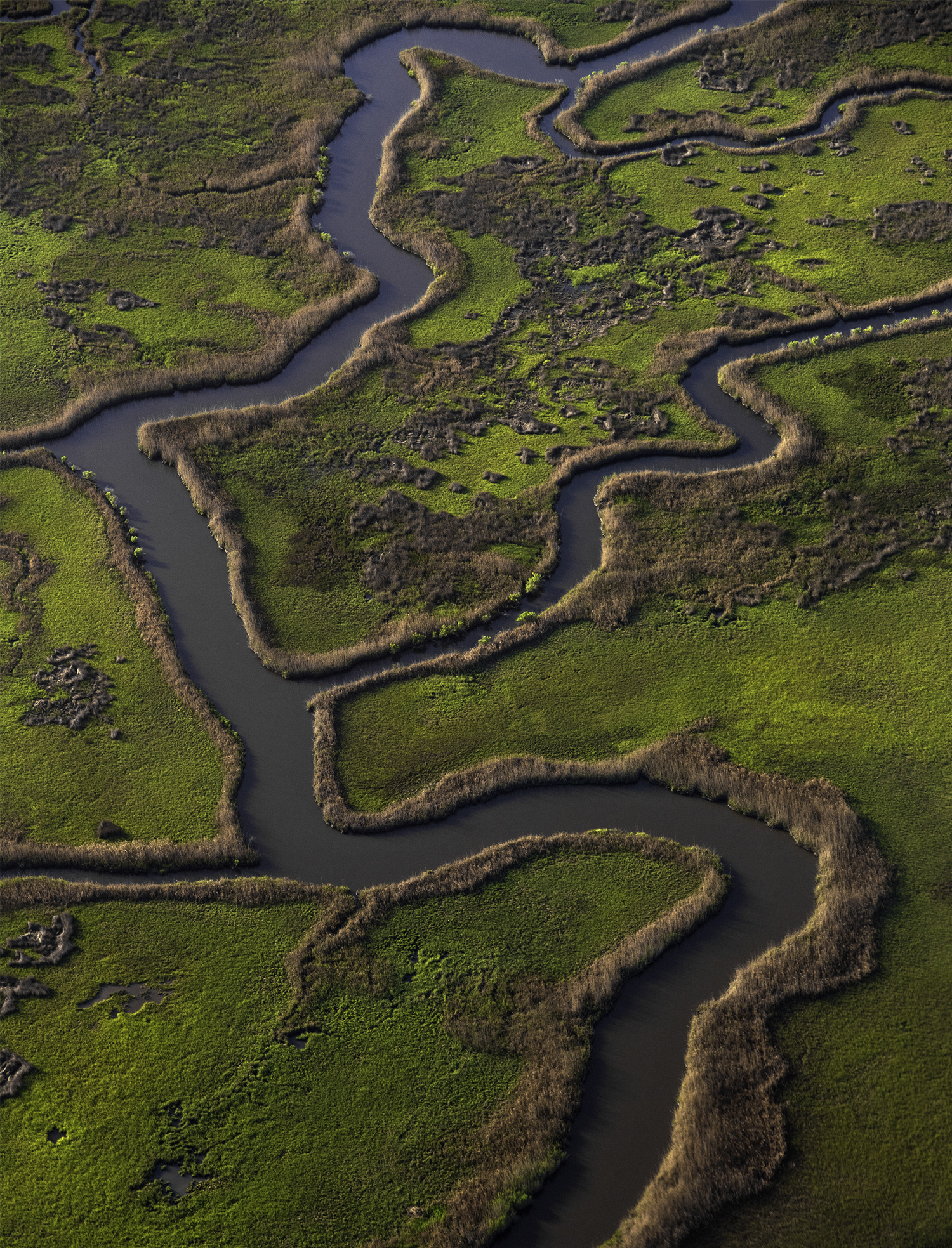
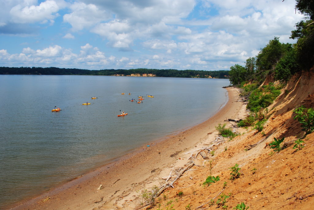
Fall is the perfect time to get out and explore the Bay’s tributaries by paddle.
Some years ago, I got to paddle Blackwater National Wildlife Refuge on Maryland’s Eastern Shore. Blackwater is one of the largest wildlife refuges on the Delmarva peninsula, and if you want to feel truly humbled by nature and by history, I highly recommend it.
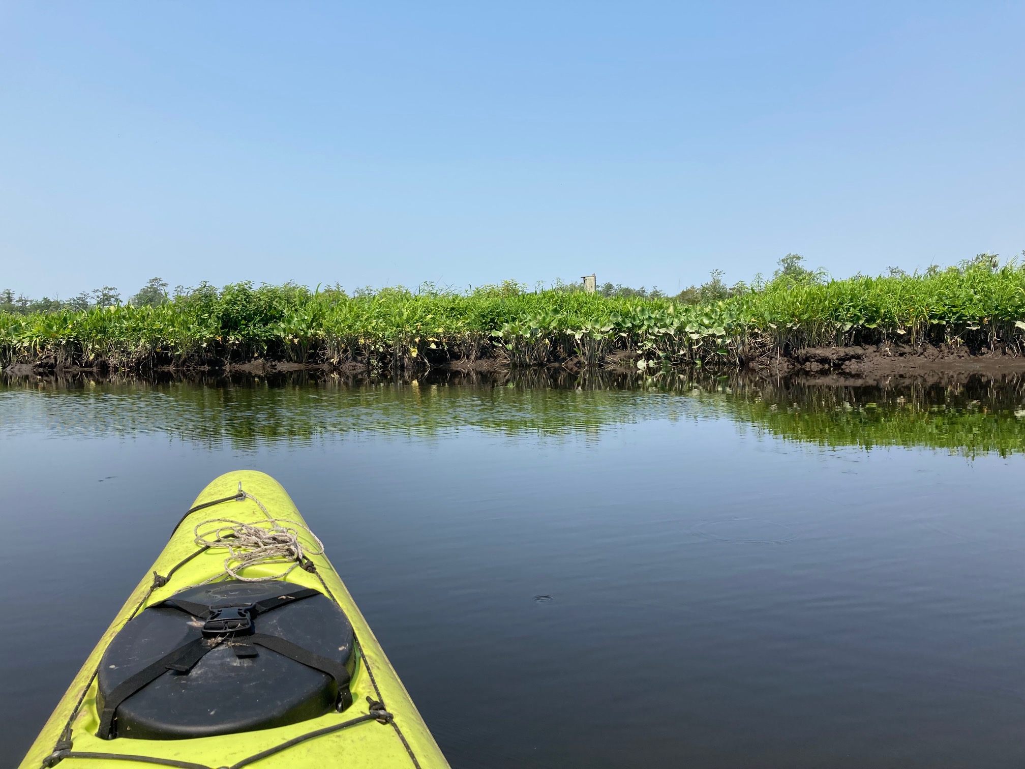
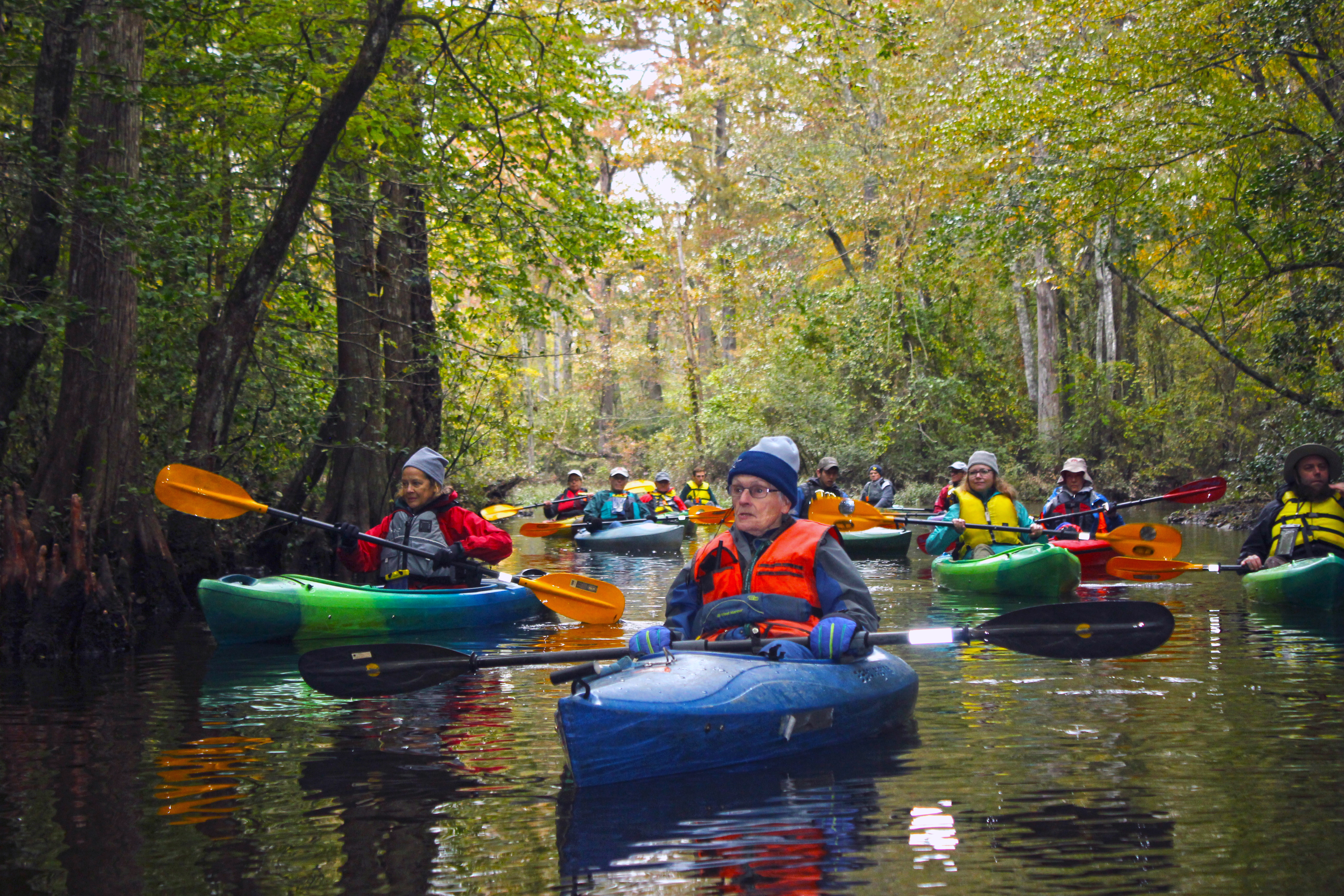
We must have looked like floating crayons that day in our vivid kayaks, but the bald eagles and ducks overhead paid us no heed; the eagles circled low in search of fish, while the ducks squawked in alarm. We were a party of three, all alone with the birds in a landscape that looked much like it did two hundred years ago—minus the trees cut down to become ships and islands since swallowed up by the rising sea.
I remember our guide, Susan Meredith, pointing out a beach. At places like this, she told us, a famous Dorchester Countian once guided others to overnight shelter. Moving in darkness, they waded on sandbars, avoiding the Blackwater River’s quicksand-like mud. “What Harriet Tubman did, she’d walk over to those islands,” Meredith said, before explaining how Tubman led her enslaved friends and family to the swampy hideouts she’d known since childhood, the first stop on their journey to freedom.
The Chesapeake has hundreds of places like Blackwater, where nature and history are best contemplated quietly in a kayak or canoe. Virtually every county along the Bay now offers water trails complete with maps and suggested itineraries paddlers can use to plan their journeys. We’ve chosen a sampling of these so you can plan your own excursion and see the wonders of the shallower waters of the Chesapeake Bay through your own eyes.
Tobacco Rowed:
The Sassafras
Centuries ago, agricultural ports lined this 22-mile-long river on Maryland’s upper Eastern Shore, which runs from western New Castle County, Del., to Betterton, Md., where it empties into the Bay. That schooner has long since sailed, ceding the Sassafras to powerboaters, paddlers and workboats. Narrow and forest-lined near the upriver town that shares its name, the Sassafras widens as it flows due west to the Bay. Lining its shores, you’ll find explorable creeks, a preserved tobacco plantation, water lily-like plants bigger than your head, and a speedy, sand-dwelling insect found almost nowhere else.
Destination: Turner’s Creek
Length: 4 miles
Put In/Take Out: Turner’s Creek landing
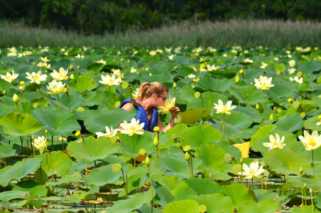
A natural harbor on the lower Sassafras, Turner’s Creek is the river’s most popular paddling site, noted for pristine scenery and a profusion of American lotus plants. “In mid-summer months the creek is filled with blossoms,” says Chris Cerino of the Sultana Education Foundation, which offers guided paddles. Turner’s is bordered by Sassafras Natural Resources Management Area and Turner’s Creek Park. Just downriver on Lloyd Creek, watch for bald eagles and an endangered beach dweller, the Puritan tiger beetle.bde6ffA natural harbor on the lower Sassafras, Turner’s Creek is the river’s most popular paddling site, noted for pristine scenery and a profusion of American lotus plants. “In mid-summer months the creek is filled with blossoms,” says Chris Cerino of the Sultana Education Foundation, which offers guided paddles. Turner’s is bordered by Sassafras Natural Resources Management Area and Turner’s Creek Park. Just downriver on Lloyd Creek, watch for bald eagles and an endangered beach dweller, the Puritan tiger beetle.
Destination: Upper Sassafras
Length: 5.5 miles
Put In/Take Out: Foxhole Road landing
If it’s solitude you seek, get thee to the upper Sassafras. Narrow and forest-lined, this stretch of river should be tackled at high tide; the water’s skinnier than a heron’s bill by the time you near the town of Sassafras. As you paddle more than two miles upriver from Foxhole Road landing, you’ll share your surroundings with herons, kingfishers and stands of fuzzy cattails, but not many of your own species.
Destination: Mount Harmon Plantation
Tour: 2.5 hours
Put In/Take Out: Mount Harmon dock
Cerino and others lead Sultana Education Foundation guided paddles around this peninsular plantation, a thriving tobacco port when “sot-weed” was the king of crops. Paddlers get to explore the creeks—Back, Foreman’s and McGill—that surround “World’s End,” the 200 or so acres that remain of a once 1,200-acre plantation. These public paddles include your kayak and gear, plus a tour of Mount Harmon’s restored 18th-century manor house.
Critters of the Blackwater Lagoon:
Blackwater National Wildlife Refuge
This 26-mile-long river and its main tributary, the Little Blackwater River, pool into a massive tidal marsh that’s an annual layover for tens of thousands of migrating waterfowl, from blue-winged teal to tundra swans. Since 1933, their habitat has been federally protected as Blackwater National Wildlife Refuge. The year-round populations are also impressive, including the largest group of nesting bald eagles this side of Florida. Three color-coded water trails provide 17 miles of paddling pleasure.
The Green Trail
Length: 8 miles
Put In/Take Out: Rte. 335 kayak/canoe launch
Highly recommended, this easy-to-navigate trail offers the best variety of scenery and wildlife. In the fall, look for northern harriers, marsh hawks, bald eagles, black ducks, shovelers and pintails. Susan Meredith suggests a detour into Buttons Creek, which she’s nicknamed “the land of the living decoys” for its population of easily approachable ducks. If you’re hanging with the puddle ducks and dabblers during hunting season, though, wear orange and don’t go early in the morning.
The Orange Trail
Length: 7.6 miles
Put In/Take Out: Shorters Wharf ramp
A marshy, scenic route along Coles Creek, this is also an easy trail, which curls into a wooded area. Less traveled than the popular Green Trail, you’ll get to see such critters as great blue herons, bald eagles, red-winged blackbirds and muskrats. The water here can get shallow, so remember rule number one for Blackwater paddlers: Don’t get out of the boat! The marsh muck here will suck the water shoes right off your feet.
Little Blackwater River
Tour: 2 hours
Put In/Take Out: Blackwater Adventures launch site
Even experienced paddlers avoid the refuge’s third trail, a dicey, open-water route marked in purple. (It’s closed from October through March.) Instead, take Blackwater Adventures’ signature guided tour of the delightful Little Blackwater River. Watch bald eagles and ospreys, explore quiet, loblolly-lined coves and look for river otters frolicking in the water. Meredith and other guides will explain local culture and history, including ties to Tubman, whose mother was born on a tobacco farm along this river.
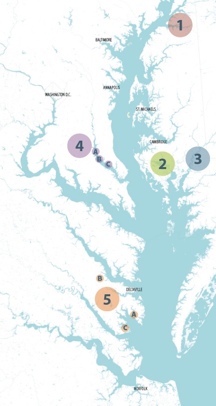
See for yourself
1. Sassafras River
- Turner’s Creek – 4 mi.
- Upper Sassafras – 5.5 mi.
- Mt. Harmon Plantation –
- 2.5-hour tour
2. Blackwater National Wildlife Refuge
- The Green Trail – 8 mi.
- The Orange Trail – 7.6 mi.
- Little Blackwater River – 2-hour tour
3. Nanticoke River
- Broad Creek – 6 mi.
- Barren Creek – 8 mi.
- Wetipquin Creek – 2 – 8 mi.
4. Patuxent River
- A Jug Bay – 2 – 4 mi.
- B Nottingham – 3 – 7 mi.
- C Broomes Island – 1 – 2 mi.
5. Middle Peninsula
- A East River – 11.7 – 13.8 mi.
- B Dragon Run – 40 mi.
- C Guinea Marshes – 2.5 – 5 mi.
Paradise Retained:
The Nanticoke
Pristine. Peaceful. Almost primal. Paddlers heap praise on the Nanticoke, the Eastern Shore’s largest, best-preserved tributary. Largely undeveloped and likely to stay that way, the watershed’s wetlands and wooded creeks support rare flora (white cedar swamps), fauna (sturgeon) and countless bird species. Some 63 miles long, the river begins in Delaware, hugs the city of Seaford and passes several small towns and swaths of wildlife preserves before spilling into Tangier Sound. Avoid the boat-busy river in favor of meandering creeks filled with bald eagles, beavers and large-mouth bass.
Destination: Broad Creek
Length: 6 miles
Put In/Take Out: Laurel River Park, Del.
Popular with bass anglers and bird watchers, Broad Creek boasts scenery galore. Narrow and tree-lined at Laurel, it widens and turns swampy as you head downstream toward Bethel, a convenient turn-around spot. Look for ospreys, herons and wood ducks, and don’t be surprised if a beaver bids you good riddance with a tail slap. Park a vehicle at Phillips Landing, a park near the creek’s mouth, to extend your paddle by about four miles.
Destination: Barren Creek
Length: 8 miles
Put In/Take Out: Mardela Springs boat ramp
Snaking through Nanticoke National Wildlife Refuge, Barren Creek delights kayakers as they round every meander. Heading west (downstream), the creekscape transitions from wooded banks guarded by loblolly pines to a marsh awash in the delightfully named water lily, spatterdock. Watch for bald eagles, herons and other waterbirds. On reaching the Nanticoke, venturesome paddlers can turn upriver (mind the tides) about a mile to reach historic Vienna on the opposite shore.
Destination: Wetipquin Creek
Length: 2 to 8 miles
Put In/Take Out: Wetipquin Park ramp or Tyaskin Park beach
An upstream paddle on a fairly short creek, this trip takes you through forests and salt marshes Native Americans once canoed. Leaving Wetipquin Park, you’ll pass a bridge and face an immediate choice: Paddle northeast on the main creek or southeast on Tyaskin Creek. Unlike poet Robert Frost, you won’t second-guess your pick of these divergent routes; both are scenic and bird filled. To lengthen your trip slightly, launch from the beach at Wetipquin’s mouth.
Honey, They Shrunk the Chesapeake:
The Patuxent
A gobsmacking 115 miles long, the gentle Patuxent flows generally southeast, transitioning through thick woods and tidal marshes, active farmland and sandy bluffs on its Bay-ward journey. Relatively narrow and quite deep, it’s the longest river entirely within Maryland, and nicknamed “the Chesapeake in miniature.” Officially, the trail follows the entire river, but it’s the more navigable lower half—from Bowie to Solomons Island—that’s of interest to most paddlers. If you’re considering a multi-day trip, there are eight paddle-in campsites.
Destination: Jug Bay
Length: 2 to 4 miles
Put In/Take Out: Patuxent River Park (west shore)
A freshwater tidal estuary, Jug Bay is one of the river’s crown jewels. Park-protected on both shores, it’s an oasis of wetlands, forests and tributaries where sora rails feed in fields of wild rice, muskrats and beavers lodge in nearby creeks, and archaeologists still unearth artifacts thousands of years old. Launch at Patuxent River Park’s Jackson’s or Selby’s landings and explore for yourself, or take a guided marsh tour led by Jug Bay Wetlands Sanctuary naturalists.
Destination: Nottingham
Length: 3 to 7 miles
Put In/Take Out: Nottingham
Patuxent Riverkeeper Fred Tutman grew up along the river near Queen Anne, an area he still loves. His office is 15 miles downriver at Nottingham, an unspoiled stretch of water he also recommends. His picks of campsites downstream of Nottingham: Spice Creek (5 miles), “very isolated, very private”; and Milltown Landing (6.7 miles), “gorgeous, a nice place to roll in the grass and look at the stars.” For a shorter paddle to either, put in at Magruder’s Landing.
Destination: Broomes Island
Length: 1 to 2 miles
Put In/Take Out: Nan’s Cove
This island (really a peninsula) typifies the hard-working watermen’s communities that once dominated Southern Maryland. Crabbing and oystering aren’t the fisheries they once were, but there are still plenty of fish in the Patuxent. Launch at Nan’s Cove, a small park just upstream of Broomes, and go kayak fishing for white perch and catfish. The cove is well sheltered, making it ideal for a family outing. Adjacent coves invite additional exploration.
Deck Boats and Dragons:
The Middle Peninsula
Along with its neighbor, the Northern Neck, this is what’s called “Rivah Country.” Bounded by the Rappahannock River to the north and the York to the south, Virginia’s Middle Peninsula is defined by winding rivers, deepwater creeks and a beautiful bay that spills into the Chesapeake; in short, it’s a paddlers’ paradise. The peninsula’s eastern counties—Gloucester, Mathews and Middlesex—offer nearly 900 miles of shoreline to explore, including a maritime heritage trail and an enchanted stream like one that Tolkien would have created.
Destination: East River
Length: 11.7 to 13.8 miles
Put In/Take Out: Williams Wharf or Town Point Landing
Centerpiece of the Mathews Maritime Heritage Trail, this five-mile-long Mobjack Bay tributary is lined with historic wharves, ex-shipyards and grand estates, including Poplar Grove, briefly owned by John Lennon and Yoko Ono. (Look for its unusual sidekick, a tide mill.) Williams Wharf, three miles upstream from Mobjack, divides the river’s lower, wind-exposed section from its sheltered upper waters, which fork west and east. The former offers inviting creeks; the latter leads to Mathews via ultra-shallow Put In Creek, site of a town kayak launch.
Destination: Dragon Run
Length: 40 miles
A cypress swamp draped in moss. Darkened waters in a forest primeval. A plant that plays possum. It’s not Middle-earth, it’s Dragon Run, a remote, brackish stream that becomes the Piankatank River. One of the Chesapeake’s most ecologically significant waterways, “The Dragon” holds many wonders, including featherfoil, an aquatic wildflower favoring beaver ponds, and the drought-detesting resurrection fern, which appears dead until rehydrated. Not easily accessed, Dragon Run is best paddled on guided tours led by the Friends of Dragon Run.
Destination: Guinea Marshes
Length: 2.5 to 5 miles
Put In/Take Out: Maryus Road/Maundy launch
The peninsula offers paddlers another unique environment: the salt marshes of the Chesapeake shoreline. A narrow inlet in Gloucester County, Maundy Creek provides access to once-inhabited Big Island, gateway to the Guinea Marshes fishing grounds. Watermen (“Guineamen”) abandoned Big Island, now a seabird nesting site. Oyster and mussel beds still line the island, and at low tide you’ll see sandpipers and plovers wading the flats. Watch for diamondback terrapins, cobia and cownose rays too.