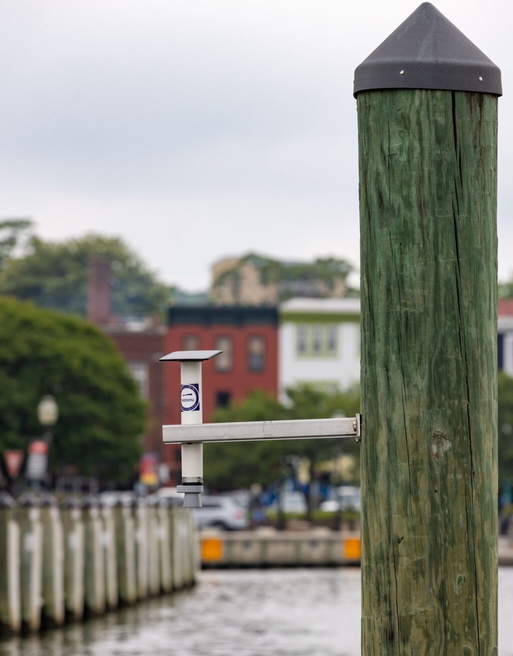
On a recent sunny morning at the Annapolis City Dock, local officials, climate scientists from the University of Maryland, and a Hawaiian company announced new steps Annapolis is taking to combat the flooding that repeatedly disrupts businesses, drivers and visitors. The first step, just unveiled, is a Hydronet sensor installed in Ego Alley. It’s one of more than a dozen now found in and around the Chesapeake Bay to assist forecasters, climate scientists, and you.
A QR code near the Hydronet leads you straight to real-time data intended to guide scientists, but also anyone who is affected by flooded roads, business disruptions, access to or by first responders, and all of us who boat in and around the Chesapeake Bay.

If you’ve ever wondered about adjusting spring lines or maybe a pre-emptive haul-out in the face of an impending storm, this data can help to answer these questions.
The Maryland Climate Resilience Network (MCRN), an initiative aimed at preparing Maryland for future climate change impacts, worked with Hawaii-based startup Hohonu to install a network of Maryland Hydronet sensors. They provide real-time data on water levels so that communities can anticipate and respond to flooding events more effectively. Scientists will also use the data for long-term planning.
Dr. Brian Glazer of Hohonu demonstrated the phone app and showed how the device captures sonar based data (think bats catching insects at night) and relays the data via cell signal every second. It produces near real-time water level monitoring. When compared to a nearby NOAA monitor, the Hydronet device was more accurate by over a foot—which can make a huge difference in the decision-making process for boaters, first responders and parents deciding when to pick children up from schools.
Annapolis Mayor Gavin Buckley said, “So we are on track to have the highest flooding this year in the history of this city.” According to the City of Annapolis at the current pace, Maryland’s capital will see 120 or more flooding events, a huge number compared to the record of 65 flooding days in 2019.
Buckley went on to say, “We like big ideas here in Annapolis, please keep bringing them to us. We want to be the lead. We want to be the resilience capital, it is Maryland’s time to lead.”
Buckley was talking about some of the steps Maryland has taken to ensure that its communities, infrastructure, and natural resources can withstand and recover from these impacts. Michael Henson, Maryland’s Chief Resiliency Officer, emphasized the Hydronet sensors’ role in emergency management, especially for underserved communities.
Maryland, with its extensive coastline along the Chesapeake Bay and numerous urban and rural communities, is particularly vulnerable to climate change. Rising sea levels, increased frequency and intensity of storms, and changing precipitation patterns pose significant threats to the state’s environment, economy, and public health. Flooding, coastal erosion, and heat waves are direct consequences that Maryland is already experiencing, the MCRN says.
Hohonu’s sensor system allows users to monitor tidal conditions as they happen, detecting even slight changes in water levels. You can access the system remotely on its app or on the web and add customizable alerts for any potential threats.
Made of PVC pipe and measuring at less than two feet tall, the HydroNet is a solar-powered sibling of the Maryland Mesonet, a network of weather-measuring devices that can help Maryland be ready for severe storms this hurricane season and beyond.