Engineers apply erosion in reverse
The large piles of mud and silt are rather unsightly. Dug from channels around the Chesapeake Bay, the glop might seem useless; but here it’s a valuable treasure that could save the Bay’s vanishing islands.
Over the past century, several Bay islands have slowly eroded both to natural causes and aggravated climate change. But while the disappearance of one or two might not seem that alarming, it can be. These islands serve as both vital wildlife habitats and barriers protecting coastal areas from storms. Thanks to a new revitalization project though, there’s hope that two of the Bay’s disappearing islands will reappear.
The Mid-Chesapeake Bay Island Ecosystem Restoration Project is a joint effort between the U.S. Army Corps of Engineers (USACE), Maryland Port Administration and the Baltimore District & Maryland Department of Transportation to rebuild these essential Bay components. The project has been brewing since 2009 and is designed to restore Barren and James islands. Construction was officially authorized in 2014.
“In the last 150 years it has been estimated that 10,500 acres of this type of island habitat have been lost in the middle-eastern portion of Chesapeake Bay due to erosion and climate change,” says Cynthia Mitchell, a USACE Baltimore District spokesperson. “By restoring and expanding it, it will rebuild the shoreline and create a haven for wildlife. It will also provide direct benefits of improved health, richness and sustainability to aquatic and wildlife species and indirect benefits of navigational safety and education.”
In September 2022, a $43.1 million contract was awarded to the U.S. Army Corps of Engineers for the restoration. The funds, made possible by the Bipartisan Infrastructure Law, will restore up to 2,072 acres on James Island and 72 acres on Barren Island. The projects should be completed by 2067 at an estimated total cost of $4 billion.
“We are very happy to be working on this exciting project with our great partners at the Army Corps of Engineers,” says Richard Scher of the Maryland Port Administration – Port of Baltimore. “Rebuilding James and Barren Islands is an environmental and commerce win-win.”
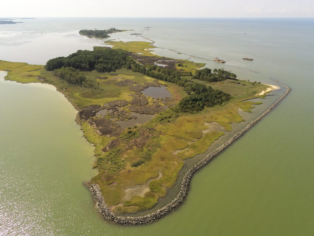
Situated along Maryland’s Eastern Shore near Upper Hooper Island, Barren Island was popular farming and hunting grounds until around the early 1900s when significant erosion began. By 1916, most families had left, but hunting remained popular. Eventually, humans left the island for good, and in the early 2000s a hunting lodge, one of the last remaining structures, was swept away. The island has lost 42 acres over the past two decades alone.
James Island, a short boat ride north of Barren Island toward Little Choptank River, was once a vast 1,300 acres in the mid-1800s. The islands share a similar story. By 1910, most families (primarily farmers) were gone, but it wasn’t completely abandoned. In 1916, local Clement Henry released imported Sika deer on the island in an attempt to make the spot a hunting destination. While his wish did come true, nature slowly reclaimed James Island until it was only 550 acres by the 1990s and eventually deserted.
While the Bay has slowly devoured these islands, engineers are planning to use dredged material to reverse the process. Dredging is a common practice around the Bay, where silt washed from the shores by wind and wave action tends to fill up the channels. This is especially true in Baltimore Harbor, where channel depths and widths need to be maintained for safe ship navigation.
“Dredging will keep happening because channels need to keep being dug,” says Jackie Specht, The Nature Conservancy’s Resilient Coasts Program Director for Washington, D.C. and Maryland. “Rather than just putting the material in storage on land it’s used instead to create habitats and marshes across the Bay.”
The USACE dredges around five million cubic yards each year from these channels and anchorages—material that needs to be disposed of in an eco-friendly way. “This project implements a long-term strategy for providing viable placement alternatives to meet the dredging needs of the Port of Baltimore while maximizing the use of dredged materials as a beneficial resource,” says Mitchell.
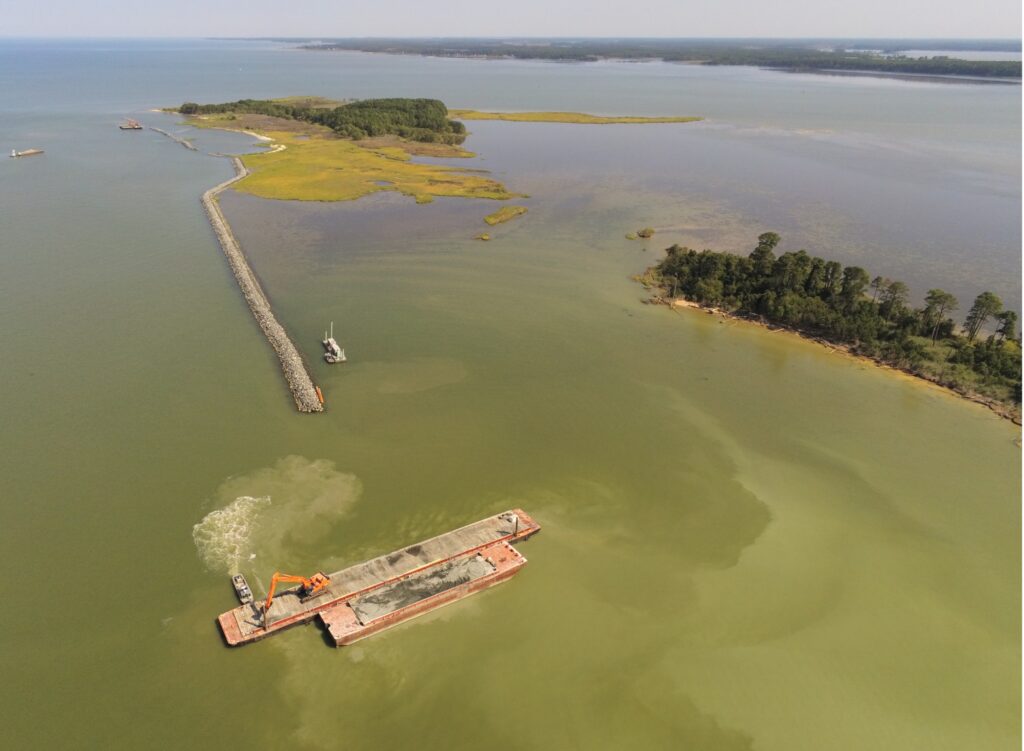
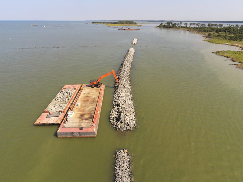
To dredge an area, a hydraulic dredging system or mechanical dipper digs into sea beds to collect sediment, which is later transported by barge to the desired island. The material is then dumped, filled in and later drained out and sculpted. It’s an intricate process but one that has lasting results as it forms the islands into a stronger land mass.
For James and Barren islands, the dredged material will come from a few different areas. James Island will receive sediment from federal navigation channels that serve as Port of Baltimore approach channels. These likely include Swan Point Channel, Brewerton Channel and Tolchester Channel. Barren Island will get its material from local small federal navigation channels with potential sources being Upper Hooper Island’s Back Creek and the Honga and Tar Bay channels.
Barren Island is the project’s current focus and will be restored to its original footprint. Once completed, up to 83 acres of wetlands and 1,325 acres of nearby seagrass beds will be established. The island’s first reconstruction phase began earlier this year and involves installing breakwaters and stone sills to contain the dredged material. The process is estimated to last until October 2024. Depending on how things go, dredged material might also start being added next year. One of the biggest hurdles will be safely transporting equipment and supplies to the land. “It’s a complex process due to the remote nature of the project and poses an added challenge,” Mitchell says.
James Island won’t receive attention until 2030 and will undergo a much more extensive rebuild. Once complete, the island will be 2,100 acres—800 acres bigger than its original size. It will be a mixture of upland and wetland habitats.
Both islands are being designed with sea level rise in mind and should last for at least 50 years.
To watch Cheryl Costello’s first look at the construction underway that will transform these islands, go to www.youtube.com/watch?v=NkOh0rXK8ms
Rachel Kester is a Virginia-based freelance writer who covers topics ranging from the environment to culture.