Eric Gladhill knows south-central Pennsylvania pretty well. He was raised and still lives in Fairfield, works less than 10 miles away in Gettysburg, and as a surveyor has tramped the Pennsylvania-Maryland border extensively. He even wrote a book about his surveying adventures. But on a warm day last June, he lost his way in the woods, and I was with him.
The directions he had were 30 years old. The object he was looking for had been there at least a century, maybe two. And it was only about the size of a toaster oven stood on end.
We were exploring the nation’s most storied boundary, the Mason-Dixon Line. Specifically, we were looking for one of the stone markers—called monuments—that 18th-century Englishmen Charles Mason and Jeremiah Dixon placed at one-mile intervals along the border line that now bears their names.
Gladhill was using mapping apps, and the marker’s approximate coordinates and outdated instructions on how to find it. But after leaving the neatly mowed lawn of a modernish house in Adams County, we wandered the woods at length on a treasure hunt of some urgency.
Gladhill was one of about two dozen Maryland and Pennsylvania surveyors who volunteered to locate and document these aging landmarks. Most original monuments—stone pillars embedded in the ground over two centuries ago—still exist; some have been replaced, a few are missing. They wear the scars of time, weather, neglect, and maltreatment—accidental or intentional. Monuments have been buried, broken off, tipped over, plowed under, shot at, stolen, dumped, defaced by souvenir hunters, and repurposed as church steps, curb stones, platforms for mounting horses, and building blocks for farmhouses and barns.
The monuments themselves belong to the states whose border they mark, but they’re often located on private lands where some owners find them more hindrance than history. When Maryland’s and Pennsylvania’s monuments were inventoried in the early 1900s, the federal surveyor’s report bemoaned “the far too prevalent notion that a landowner has a right to dispose of a monument in accordance with his own desires.”
Historically, the Mason-Dixon Line has been a sort of fulcrum, tipping favorably for one entity, less so for another. It was surveyed from 1763 to 1768 to settle a territorial dispute between Pennsylvania’s and Maryland’s governing families, the Penns and the Calverts. If things had gone Maryland’s way, latitudinally the line would be farther north and the state could now claim two major East Coast seaports: Baltimore and Philadelphia. A half century after it resolved one land dispute, it came to symbolize another when the nation split over slavery and the line meant, for many, the difference between enslavement and freedom.
Surprisingly, only monuments along the less iconic border that separates Delaware from Maryland and Pennsylvania—a line also surveyed by Mason and Dixon—are federally protected historic sites. (The Delaware Boundary Markers were placed on the National Register of Historic Places in 1975.) That’s why Gladhill and his colleagues engaged in a time-sensitive quest to find and assess Pennsylvania’s and Maryland’s monuments. The National Register imposes on applicants a two-year limit for gathering and submitting data and the Mason and Dixon Line Stone Inventory launched at a most unfortunate time: mid-March 2020. Field work was soon halted due to the pandemic and didn’t fully resume until 2021, a loss of valuable months.
The Maryland Geological Survey is overseeing the project on behalf of the state, which by law is supposed to inventory the stones every 10 years but basically can’t afford to. This time the stakes are higher. Chris Connallon, a geologist with the agency, is keeper of the inventory database.
“They’re important historical artifacts we need to preserve for future generations,” he told me, referring to the 221 monuments along Maryland’s and Pennsylvania’s border. A National Register listing, if approved, could mean grants and other funding needed to preserve the stones—money neither state can currently provide, he said.
Even with a two-year window, surveyors faced a daunting task: locate, obtain precise coordinates, and assess all of the monuments, about a third of which lie in the states’ westernmost counties, where mountains and deep woods do battle with GPS satellite signals.
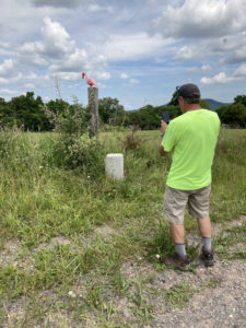
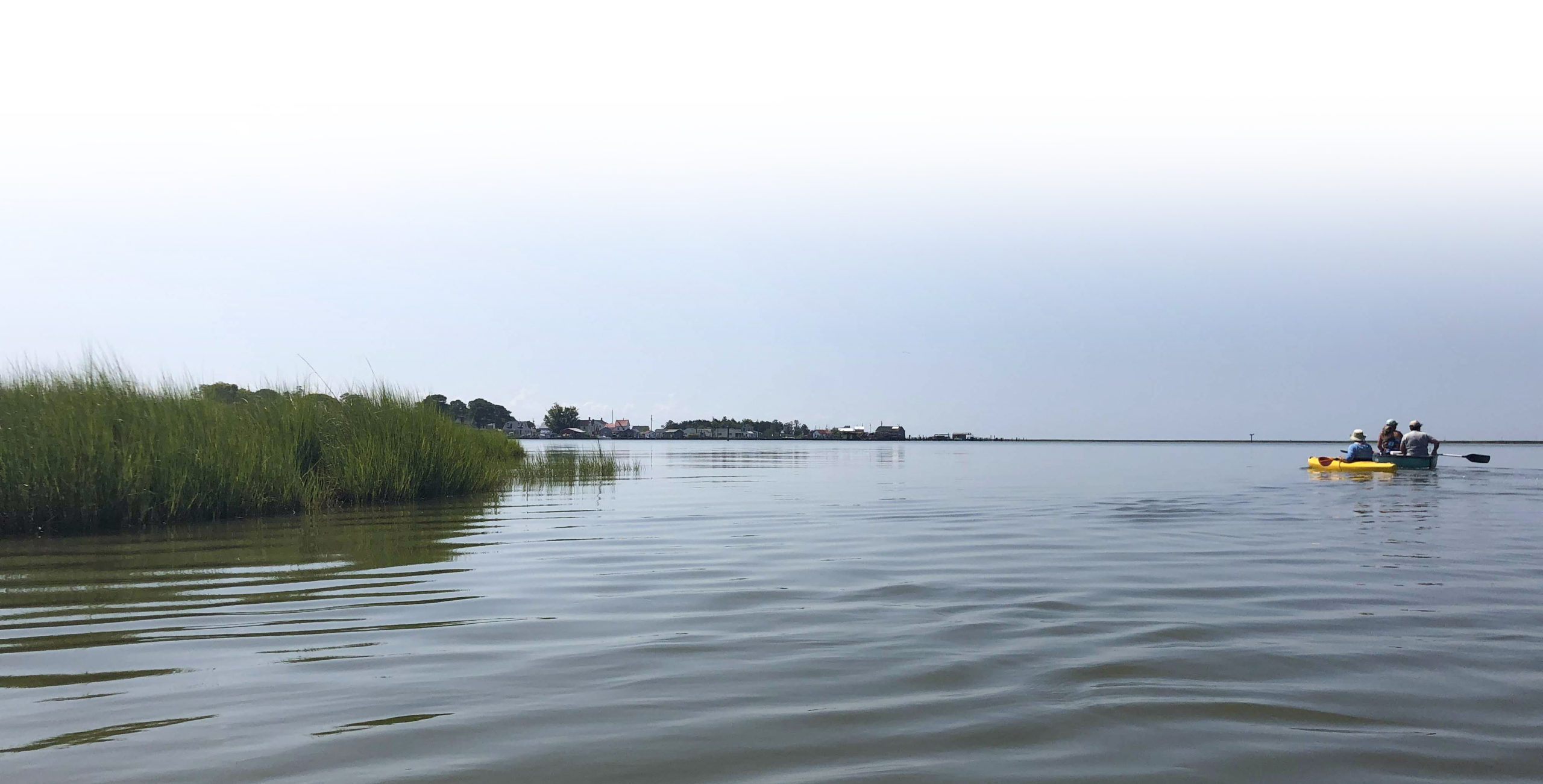
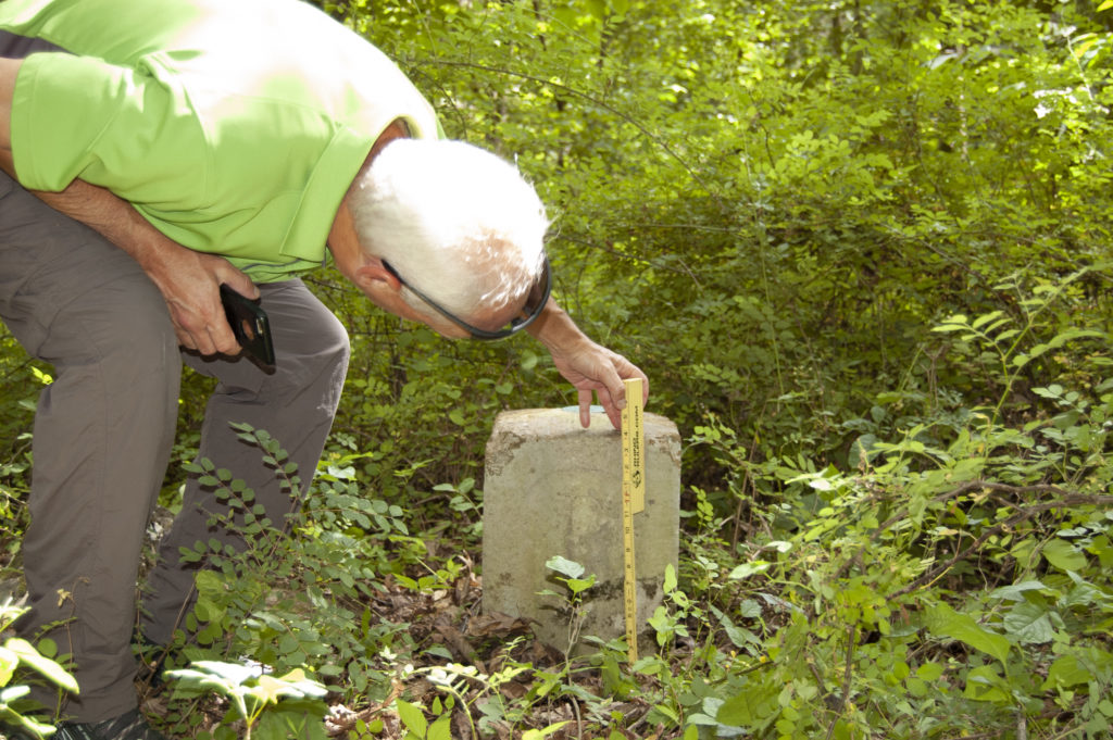
The monument Gladhill and I were looking for that day was Milepost 79, situated in the more GPS-friendly east. (The numbers—which don’t appear on the stones—refer to the distance from Mason’s and Dixon’s starting point, Mile 0 at the northeast corner of Maryland.) The property owners didn’t know its location, so Gladhill consulted a previous surveyor’s directions. They sounded simple: Follow a woods road for 400 feet to the monument site. There were woods all right, but no longer a visible road. For about an hour, we climbed over fallen trees and mossy rocks and fought through heavy undergrowth searching for a stone placed here when the terrain was far wilder and more forbidding.
“I should have brought a machete,” Gladhill mused. The special resurvey app that Connallon designed suggested such a precaution. Under the category for describing monument accessibility, the first example was, “Bring machete, site is overgrown.” Mason and Dixon used “axmen” to clear the way as they blazed sightlines through the wilderness.
As Gladhill consulted his phone apps and adjusted our direction periodically, the only noises we heard were the forest inhabitants’: a croaking frog, a busy woodpecker, and this being 2021, the insistent chorus of Brood X males clamoring for cicada sex. Finally, Gladhill spotted a blue-blazed tree marking the owners’ property line. He said the state line had to be nearby. Spying a severely weathered fence post, he followed the fence line for a few yards and called out, “There it is!”
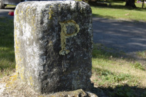
Clearing away poison ivy, Gladhill uncovered a squat, chalky white stone poking about a foot and a half above ground. It had a “P” chiseled on the Pennsylvania (north) side and an eroded “M” on the Maryland (south) side. (Some stones are more ornate. Set at five-mile intervals, “crown stones” bear the coats of arms of the Penn and Calvert families in place of letters.)
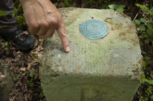
Stone 79’s corners were chipped, it sprouted tufts of moss, and there was a tarnished, 20th-century U.S. Coast and Geodetic Survey (USGS) disk embedded in the top. Gladhill unfolded a ruler and measured it. The stone was the size of Mason’s and Dixon’s original monuments, 12 inches square. Could this be one they had installed?
Likely not, I learned later. Although 79 was quarried and carved in England like its cousins, it’s not the monument the famed surveyors ordered set here. By the early 1900s, that monument had been removed and lay so badly broken it couldn’t be repaired. In 1902, the USGS replaced it with a spare monument, one of a dozen or so shipped from England that Mason and Dixon had stashed
as spares.
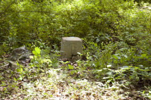
A chatty man with pale, close-cropped hair that accentuated his outdoorsy tan, Gladhill was happy to show me a genuine Mason and Dixon stone nearby. Perched on an embankment well above reach of a gentle creek, Milepost 77 was as chipped and mossy as 79, but it looked newer. Its letters were more distinct, and it bore other chisel marks left by a long-ago stone mason. Records show Mason and Dixon surveyed the site in 1765 and had the stone set in October 1767.
“This creek looks pretty much the same as it did when this was put here,” Gladhill said. When the site was initially surveyed in 1765, Mason wrote, “crossed creek … here 2 chains wide,” referring to the 66-foot-long, linked-metal instruments the surveyors used to measure horizontal distance.
Not a great deal is known about Mason and Dixon, although both were English surveyors and astronomers. Mason was the more accomplished, serving as assistant observer to the Astronomer Royal in Greenwich, where he perfected the use of lunar tables to determine longitude at sea. (The tables eventually became a guide for British mariners.)
The two men arrived in Philadelphia in November 1763 and for nearly five years conducted their now-famous survey, the first geodetic survey done in America. Based on handwriting in their field journal, one historian judged Mason to be “a cool, deliberate, pains-taking man” and the younger Dixon to be his opposite, “a man of an impatient spirit and of nervous temperament.”
Whatever their personalities, it’s clear they were given state-of-the-art equipment with which to work and used it with considerable skill. In addition to surveyors’ chains, they brought specialized equipment: a Hadley’s reflecting quadrant (a precursor to the sextant), two reflecting telescopes, an astronomical clock, and a catalogue of constellations compiled by the Astronomer Royal to consult when making celestial observations. The catalogue proved exceptionally accurate for its day. Its coordinates for the southernmost point of Philadelphia (15 miles south of which Mason and Dixon were told to draw their famous east-west line) differed from the latitude shown on today’s maps by just two and a half seconds of arc.
The surveyors’ most sophisticated piece of equipment was a six-foot-long “zenith sector,” a vertically mounted telescope built by Greenwich Observatory’s instrument maker, John Bird. With it, they could make impressively accurate celestial observations.
“They’d use that to determine their latitude. They had to lay on their backs to look through it,” explained Patrick (Pat) Simon, chief of land surveys for Baltimore County and a member of the Mason-Dixon Line Preservation Partnership, a group of surveyors and historians founded in 1990 to document and save the monuments. A delicate instrument, the zenith sector was protected by a large tent when in use and traveled by wagon on a feather bed to cushion its ride. (History doesn’t record who got the feather bed when the zenith sector wasn’t in repose.)
Mason and Dixon employed another Bird-made instrument, a transit. These tripod-mounted telescopes were used almost daily to extend the line through the wilderness as the surveyors marked their westward line. The zenith sector was lost in an 1897 fire that destroyed Pennsylvania’s state capitol, but one of the surveyors’ original transits was discovered hidden beneath floorboards in Philadelphia’s Independence Hall, where it’s now displayed.
“People think that Mason and Dixon just had a compass, like a ship’s compass, but for their time they were using what would be the best equipment available,” Simon says. “What we found was that given the conditions they were dealing with, [their work] was just phenomenal. People have compared it to landing a rocket ship on the moon.”
“All this methodology to be able to find out where they are in space,” geologist Connallon said of Mason’s and Dixon’s star-gazing accomplishments. “I’m in awe at their ability to make an even-spaced line crossing terrain using spots in the sky.”
Two weeks after my trip with Gladhill, I met Simon and a handful of other surveyors who’d volunteered their Saturday to locate monuments along the line’s midsection near Hancock, Maryland. There was a so-so chance of finding a 1700s-set stone here.
When Mason and Dixon reached Sideling Hill (“Sidelong” Hill, as they called it) west of Hancock, they set their last monument at the hill’s eastern base. The survey party’s wagons couldn’t haul 600-pound blocks of limestone over roadless mountains and forests. Instead, they mounded earth or stones six to eight feet high, setting wooden stakes on each mound to mark the surveyed line. Monuments were added later, when the sites became more accessible.
The surveyors I met were pretty cool people to hang out with. They were dedicated, inquisitive, eager to share what they knew, and modest about themselves and their profession. They’re also resourceful in the field, ready to deal with anything from black bears fiercely protective of their cubs to landowners deeply suspicious of their government. (When you need to access private property, it helps to be personable, not pushy.)
Their illustrious predecessors were, by necessity, even more adventurous. Mason, Dixon, and their workmen endured snow (up to two feet), bitter cold (22 below zero once), stifling heat (over 100 on at least one occasion), perilous terrain, and quarreling Native Americans who ultimately halted the surveyors’ mission. In October 1767, tribe members escorting the survey party refused to accompany the group westward into a rival’s territory.
On the Hancock foray, I joined Rob Kundrick, chairman of the Appalachian chapter of the Maryland Society of Surveyors, who signed up to inventory five monuments west of Sideling Hill. We found four, three of them easily.
One was a heavily eroded stone in the front yard of a hilltop farmhouse. Another was so clean and white it looked like someone tended it regularly, as you would an exotic houseplant. (It was also guarded by a pink flamingo lawn ornament impaled on a fencepost.) The third was also beside a road, but it had been turned 180 degrees—perhaps inadvertently by a highway crew—so the P was on the Maryland side and vice versa. The fourth stone we found with some difficulty, down a rutted farm lane, through the woods near the banks of a creek. Covered in moss, barely six inches of it was still visible above ground.
In 1995, Preservation Partnership surveyors began using GPS for the first time to precisely locate Mason-Dixon monuments up to about Sideling Hill. “From Stone Zero, they have basically all of them [measured] to centimeter level,” Simon told me. West of that “they took a lot of photos and did written descriptions of where to find the stones. Not as many were located down to the centimeter level because you’re getting into the mountainous region where it’s harder to do fieldwork.”
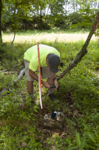
The 2020–2021 resurvey took Mason-Dixon Line mapping technology a step further, employing Geographic Information System software for the first time. Connallon’s GIS mobile app allowed surveyors to input information about the monuments—coordinates, site descriptions, monument dimensions, conditions, and photos—and upload them from the field.
Their instruments differed, but the line’s modern-day surveyors shared one thing with their predecessors. “We were both using astronomical satellites to figure out where we were,” Simon said. “We were using man-made satellites where Mason and Dixon were using God-made satellites.”
The resurvey’s status remained unclear as the March 2022 deadline loomed. By mid-December last year, Connallon had received data on 101 monuments with slightly more than that number to go. He said the National Registry indicated it might grant pandemic leeway, but he wasn’t sure how much time the project had. He doubted Maryland would be allowed to submit a partially finished list of monuments.
“Each individual stone is less important than the entire line,” he said. “It’s the line, the event, and what it represents that’s significant.” If, ultimately, the application is accepted by the National Registry, Maryland and Pennsylvania may finally be able to repair, replace, and maintain their historic monuments. They’ve done so on a very limited basis thus far.
The bistate Preservation Partnership made a significant discovery several years ago when surveyors uncovered what remained of Crown Stone 40 buried beneath a farm field in York County, Pennsylvania. It was last seen in 1902, when a survey crew located but could not reset it after the landowner objected. Enduring another century of agricultural activity, the stone was about cinder-block-sized when rediscovered. The partnership had a replica made, which now stands beside the stump of the original.
Remarkably, most monuments remain. Three are listed as missing: two are buried or unrecoverable, and a third was removed by a farmer and dumped in a ditch. That stone, however, has earned a place of high honor.
Recovered by Preservation Partnership surveyors, the 1766 English-quarried milestone was moved from its ignoble resting place on a western Maryland farm to Philadelphia during a celebration of the Mason-Dixon Line’s 250th anniversary. Reset in a cemetery where Benjamin Franklin and four signers of the Declaration of Independence rest, it marks the grave of Charles Mason, who eventually returned to the land that he measured and came to admire.