One of the best things about growing up was fishing with my father on the Chickahominy River. We’d drive east from Richmond, stop in Providence Forge for breakfast and bait, and then head to Sherman Jefferson’s landing on Chickahominy Lake, to rent one of “Jeff’s” wooden skiffs and clamp our green, five-horsepower Johnson outboard onto its transom. One part of the magic was the bass and bream (bluegills) in the lake. The other was the fact that Jefferson, an expert riverman, and his family were Chickahominy Indians. Chickahominy, in the tribe’s Algonkian language, means People of the Coarse-Pounded Corn. In January 2018, after a long struggle, the tribe gained federal recognition.
We also fished lower lake out of Ed Allen’s landing, which is still in operation under the family’s third generation. Today, people know the Chickahominy by the signs bearing its name as it flows back and forth beneath Interstate 64 between Richmond and Williamsburg. At eighty-seven miles in length, it’s a major Chesapeake tributary rising fifteen miles northwest of Richmond. Chickahominy Lake came into being in 1943 when the War Department erected Walker’s Dam at Lanexa to ensure a water supply to the Newport News Shipbuilding & Drydock Company and nearby military installations. After the war, the City of Newport News bought the dam to supply water to its growing population. There is a manually operated lock in the dam that allows a few boaters and fish to move back and forth. The dam altered the river’s dynamics significantly, especially in reducing the herring and shad runs that Sherman Jefferson and Ed Allen grew up fishing commercially.
The river below Lanexa is tidal-fresh water, rimmed by cypress trees and broad, wild-rice marshes, flowing twenty-two miles south to join the James River six miles above Jamestown and nine miles by road west of Williamsburg. We fished the lower river too, and during my career with the Chesapeake Bay Foundation, I found excuses to ply the river with canoe fleets and my trusty skiff.
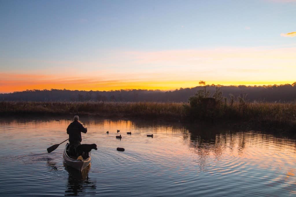
For folks who appreciate fish, birds, and Chesapeake history, the Chickahominy is a jewel. That’s especially true in the last several weeks of Indian Summer. The cypress trees have turned a lovely shade of russet heather to set off the reds and yellows of sweetgums, maples, oaks, and sycamores on the banks behind them. Meanwhile, the river is far enough south that some of the wild rice and pickerelweed are still flowering, adding texture and color to the marshes. The marshes are attracting migratory waterfowl while falling water temperatures are telling the largemouth bass, bream, crappie, yellow perch, white perch, chain pickerel, and blue and channel catfish to feed heavily before winter.
Four-hundred-twelve years ago, the Jamestown colonists realized that, though they had managed to build a fort on the island they had appropriated, they had not raised or stored any food for the winter. Captain John Smith went up the Chickahominy with a small crew aboard the 30-foot workboat he would use the following year to explore and chart the Chesapeake. He stopped at villages along the river and traded English goods for corn. On the third trip, however, well upriver into the swamp above today’s lake, he was captured and several of his crew were killed by Opechancanough, the warlike brother of Powhatan, the region’s paramount chief, from whom the Chickahominy were independent.
Whether you are exploring Chickahominy Lake or the river, it’s not hard to find reaches that look much the same as when Captain Smith came through. He noted the locations of several Chickahominy villages, and his map is so accurate that you can take a copy onto the river and find those very places. For example, River’s Rest, a marina/motel/restaurant about halfway up the river, sits opposite the site of Werawahon. Because the Indians saw the river as uniting its opposite banks instead of dividing them, it’s probable that over time, they hunted and farmed both, as well as foraging edible plants and trapping in the adjacent Big Marsh. There’s a lot of history here, from the tribes and Captain Smith up through fishing and timber industries, a brickyard, a shipyard, and the Civil War’s Peninsula Campaign.
Jeff’s is no longer open to the public, but at the head of the lake, near Providence Forge, Eagle’s Landing offers rental johnboats, a launch ramp, and a tackle shop geared primarily to bass anglers. Ed Allen’s, next to Walker’s Dam, offers everything from boat rentals and a launch ramp, to campgrounds, a tackle shop, and a restaurant. Want to see and fish the lake with a truly experienced guide? Captain Art Conway (Conway’s River Rat Guide Service), a retired biology professor, has been showing off the wonders of Chickahominy Lake to visitors for more than thirty years. The river below Walker’s has received more attention with the establishment of the Captain John Smith Chesapeake National Historic Trail. The James River Association, with multiple partners, has produced a splendid map and guide to exploring it. For paddling, my favorite trip is the loop around Gordon’s Island, launching from the boat ramp at Chickahominy Riverfront Park and paddling up Gordon’s Creek, into Nayse’s Bay at the east end of the island, and returning by Nettles Creek. This seven-mile trip is most pleasant when high tide in Nayse’s Bay occurs at mid-day, giving the boat a fair current for the whole trip.
The narrows off the West end of Gordon’s Island is exposed to wind and nearly 100 feet deep. It’s a reminder of the Chickahominy River’s power, and the need to be careful about weather. In more challenging conditions, there is plenty to see by simply exploring Gordon’s Creek from the park’s ramp. There’s a shorter paddling loop around the island at Big Marsh Point, upriver opposite River’s Rest. For exploring the river under power, the ramps at both River’s Rest and the Riverfront Park serve skiffs very well, and River’s Rest can even handle large cruising boats. The various creeks are plenty deep for powerboats, but be careful in the narrow channels. It’s a kindness to both the marshes and paddlers afloat to keep wakes low.
Whatever your vessel of choice, Chickahominy Lake and the River beckon you. Take a weekend and see them both. They form a very special part of the Chesapeake.