Underwater grasses continued to mount a comeback in the lower Chesapeake Bay last year, while a steady recovery also continued in upper portions of the Bay. Areas in between were a different story, as declines in the mid-section of the Chesapeake more than offset improvements elsewhere.
Overall, data from the 2024 aerial survey showed a mixed bag of results, with the Baywide acreage of underwater meadows— one of the Chesapeake’s most critical habitats— decreasing by about 1% but with diverse trends in different areas.
“This year really shows just how dynamic the system is, that we can have two very different trends emerge in different areas,” said Chris Patrick, a researcher with the Virginia Institute of Marine Science who oversees the annual aerial survey of grass beds.
Last year saw more underwater grasses in the high salinity waters of the lower Bay than had been observed since the survey began four decades ago. The Susquehanna Flats in the upper Bay also saw significant expansion. But the mid-Bay saw large losses, especially along the Eastern Shore.
Altogether, the 2024 survey found 82,778 acres of submerged aquatic vegetation, or SAV, down from 83,419 acres in 2023. That is well below the Chesapeake Bay Program goal of 185,000 acres, though it is significantly more than the 38,227 acres observed in 1984 when the survey began.
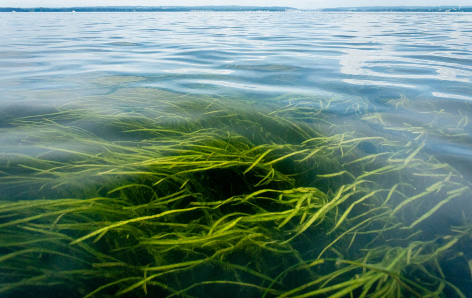
Underwater grass beds provide an important refuge for juvenile blue crabs and fish, as well as food for waterfowl. Plus, they pump oxygen into the water, their roots help stabilize sediment and their leaves buffer wave action. They are also a closely watched indicator of Bay health because the plants require clear water to get the sunlight needed to survive.
But grass beds are not the same throughout the Chesapeake. Beds in different areas consist of different species based on the salinities of the water, and they can be impacted by local factors as opposed to Baywide conditions.
That might have been at play last year in the mid-Bay where higher than normal spring river flows shifted sharply to lower than normal summer flows, potentially contributing to Eastern Shore losses, said Brooke Landry, a biologist with the Maryland Department of Natural Resources (DNR) and chair of the state-federal Bay Program’s SAV Workgroup.
The best news was in the high salinity, or polyhaline, portion of the Bay, which stretches south from the Rappahannock River and Tangier Island to the mouth of the Bay. The survey found 24,800 acres of grass in that area, a 14% increase from 2023 and the most recorded since the survey began.
It’s especially good news because the area is dominated by eelgrass, a species that is especially sensitive to warming temperatures and poor water quality and has suffered repeated setbacks over the years. As Bay temperatures have increased, polyhaline SAV coverage declined to just 11,975 acres in 2019. Patrick said the comeback was driven in part by better water clarity, which means the plants get more light and allows eelgrass to move into deeper waters — sometimes as deep as 9 feet.
Last year saw notable increases in Mobjack Bay, Poquoson Flats and nearby Western Shore areas. “It certainly looks like this is tied to improving water clarity. I mean, anecdotally, the water looks clear to me out there,” Patrick said.
The tidal fresh zone of the upper Bay and upper portions of its tidal tributaries saw a 2% increase from last year, including 10,925 acres in the Susquehanna Flats that accounts for more than half of all SAV in tidal fresh waters. Other tidal fresh zone improvements were noted in Maryland’s Northeast River on the upper Eastern Shore and in Piscataway Creek off the Potomac River.
Low-salinity areas in and near Maryland’s Gunpowder and Middle rivers bounced back from recent declines with a 46% increase. Other areas with increases included the Elk, Sassafras, Bush, and Back rivers in Maryland; the middle Potomac; and the middle Rappahannock in Virginia.
The mid-range salinity zone, which runs from near Baltimore to the Rappahannock and Tangier Island, has the largest amount of potential SAV habitat in the Bay. It suffered a 14% decline, with most of the larger losses on the Eastern Shore. The mid-range salinity area is dominated by widgeon grass, which is notorious for rapid changes linked to water quality.
Patrick points to heavy spring rains that likely washed more nutrients into the Choptank and other rivers, reducing water clarity. Landry added that the near-drought summer conditions that came after the spring rains may have contributed to losses. “While widgeon grass does have a really broad salinity tolerance, it doesn’t respond well to rapid changes in salinity particularly when stressed by water quality,” she said.
To read this story in its entirety, visit bayjournal.com.