A new partnership in Dorchester County, Maryland creates a win-win for Chesapeake Bay land preservation and the U.S. Navy.
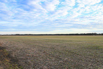
230 acres of a family-owned farm are now permanently protected from future residential and commercial development. It’s a important habitat for migratory birds, and “one of the Bay’s most pristine landscapes,” accordinging to the Maryland Department of Natural Resources.
The three parcels include 135 acres of prime farming fields and 85 acres of forest in the Nanticoke River watershed, and they connect two larger protected areas to make a 7,730-acre corridor of protected land.
That corridor is also near a flight path for aircraft out of Naval Air Station-Patuxent River, and below “special use airspace” where flight tests take place. Therefore, the U.S. Navy joined the partnership with Maryland DNR, The Conservation Fun, the Nature Conservancy, and the Chesapeake Conservancy to protect the landscape and the airspace above it.
The group of partner agencies bought an easement from the landowners, using funds from the U.S. Department of Defense, Maryland’s Rural Legacy Fund, and private funds from the Chesapeake Conservancy.
“Conserving this farm aids the military’s need to test aircraft while benefiting local communities and conserving our environment,” Chesapeake Conservancy President and CEO Joel Dunn said. “It’s a win-win situation for the Chesapeake Bay, the state of Maryland, and for the nation.”


